


With Carlson SurvPC**, get the world’s most flexible & powerful data collection software on the PC platform
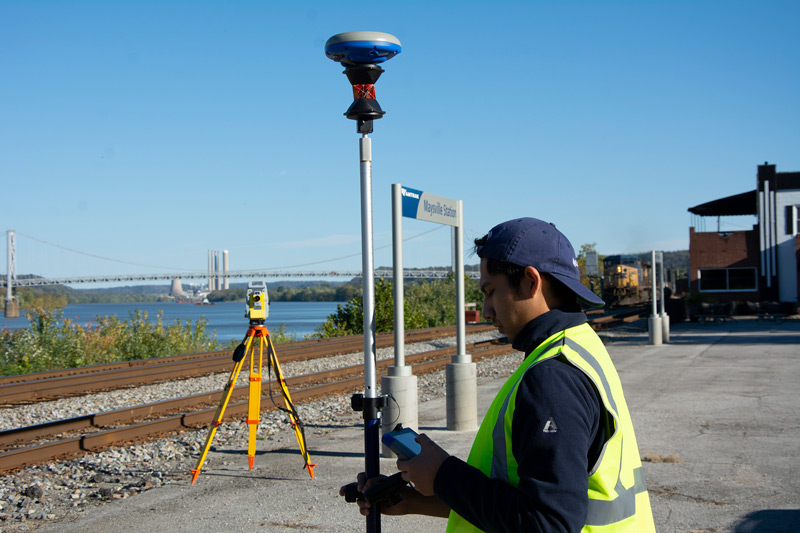
Like Carlson SurvCE, SurvPC supports the widest range of popular and new release RTK GPS and conventional/robotic total stations. Carlson SurvCE and SurvPC are complete data collection systems for Real Time Kinematic (RTK) GNSS and Total Stations with in-field coordinate geometry. SurvPC can be utilized on standard Windows PC computers such as ruggedized laptops.
SurvPC with the Esri OEM engine can load Esri maps and work natively in the Esri GIS environment. Learn how.
And then click here to see a demonstration of how SurvPC works seamlessly with Esri.
Advantages include:
- Increased hardware capability
- Increased virtual memory & ability to work with large sets of data
- Larger screen size & more convenient touch screen usage
- More processing & graphic power (with aerial photo overlays)
- Save directly to an Esri geodatabase with no import/export
- File formats compatible with Carlson office products (.fld, .flc, etc.)
- Import of MicroStation .dgn files and Import/Export of AutoCAD .dwg files is possible. Output to Excel for simple data management.
**Read how Carlson SurvPC Esri® OEM meets Norway Land Consolidation Court needs for field solution for property and land use measurement.
“...Carlson’s SurvPC offers CAD functions so close to the real thing you almost can’t distinguish the difference, which allows the user to work much like he or she would at their desk in the office.” Shawn Billings, LS, American Surveyor, read more.
http://cta-redirect.hubspot.com/cta/redirect/123057/122a2200-516b-4d45-9930-a148bd1e5f3b
Core Features
• Highly graphical and intuitive user interface is designed ‘by surveyors for surveyors’
• Easy data exchange due to rich support of CAD file formats and .dwg, .dgn, .shp
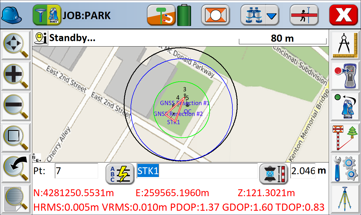
• Optional Field-to-Finish: Create drawings intuitively and automatically as you work, saving you time back in the office
• Strong GIS features with optional seamless linking to Esri® in SurvPC
• Export directly in KML format for fast control in Google Earth
• Camera integration allowing assignment of picture to points or lines
• More field capabilities with quick and easy volume calculation and ability to generate points from polylines
• True versatility: SurvCE and SurvPC run on hundreds of GPS and total station models in service today, including Altus, Ashtech, Carlson, Geomax, Leica, Pentax, Sokkia, Spectra-Precision, Stonex, Topcon, and more. See full list at www.survce.com.
• SurvCE/PC are available in more than two dozen languages: English, Spanish, German, French, French (Canadian), Russian, Portuguese, Czech, Dutch, Chinese, Korean, Greek, Italian, Polish, Hungarian, Swedish, Latvian and more.
Major Updates and New Features: SurvPC Version 7
- SurvNET in the Field provides least squares analysis for boundary survey certification and procedures to reduce error including dual baseline and time delay, with simplified results and customizable PDF reporting
- Improved blunder detection for averaging and field work
- BIM Module supports IFC and Revit files for staking, storing, and visualizing in 3D and 2D
- Reference drawing support including full layer control and automatic field update
- Esri ArcGIS Online integration to log in and update Esri database in tandem with your survey
- User created Hotlists and python scripting for advanced users allows greater customization
- Enhanced Point List and Point Information with modification history and easily editable rod heights
- Improved and fully customizable reports for coordinate, point, stake, volume calculation, and full job details now available in PDF and HTML formats
- Carlson Cloud Enhancements including automatic login, icon to indicate login status, and separate chat windows
- Tolerance Profiles for easily switchable customized tolerance settings
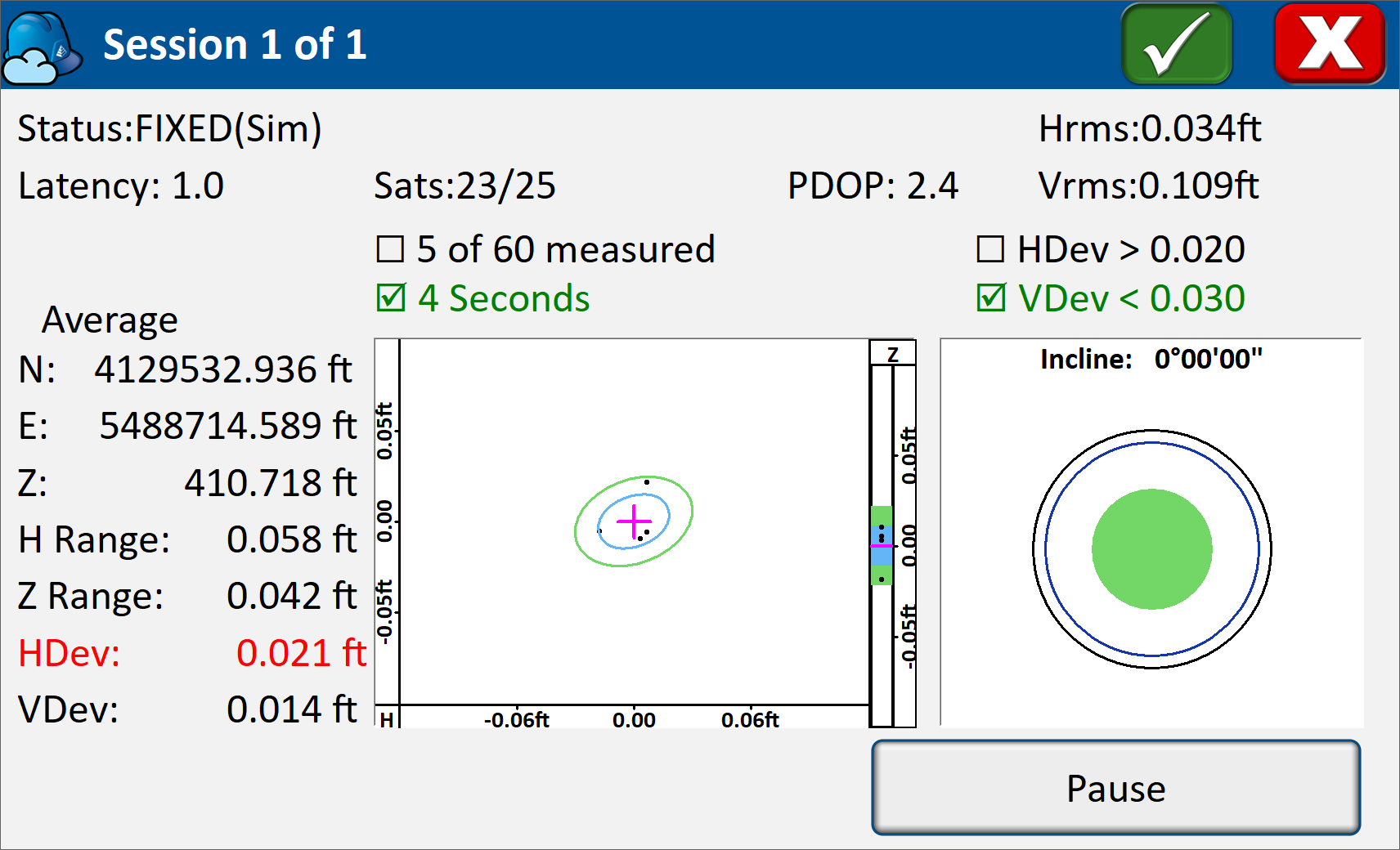
- Enhanced graphical averaging with statistics display, error ellipses in real time, outlier removal, and automatic redundancy with time delay and RTK reset
- Guided Powerline Survey with live graphing, ground surface definition, and emailed reporting of the results and environmental conditions
- Monitoring routine offers a single-station system for deformation control of bridges, buildings, etc. Email alerts when motion tolerances are exceeded
- Tunneling Module for staking any aspect of tunnels including road, dome, counter-dome, key, road, drainage
- BIM Roading Advances in road staking to support BIM and DTM models with real time sectioning
- Software Update and Geoid Download in the Field
Major New Features: Version 6
• Enhanced Search icon now available in all live survey screens with access to multiple search methods for TS/RTS
• Voice prompting In Stakeout allows users to keep their eyes on the environment while staking
• Google, Open Street Maps, Esri® Maps, and your own
WMS overlays now available in the field• GIS Inspector allows instant access to GIS attributing in the map screen
• Surface Inspector enables easy comparison of plan vs. as-built in elevation difference, making it simpler to store and stake the points that matter
• Obstructed Point Stakeout allows guided staking of unreachable points by marking azimuth and distance
• Automatic Backsight Check in the joystick screen makes it easier to check your setup at any time
• GPS Tolerance Band instantly indicates when a tolerance is exceeded in live survey screens
Hybrid+
• Mix and match any RTS and GNSS from Carlson’s vast driver library
• GPS Search is faster than any search method available
• Follow Me keeps the total station pointed where you need it by continuously tracking the GNSS location
• Smart Lock detects when you are slowing down to take a measurement and automatically locks on the prism—ready when you are
• Smart Staking provides directions from the GNSS when the total station position isn’t available, then automatically locks back on the prism when you reach your destination
• Backup Tracking — GPS position is automatically shown when total station is not tracking
• GNSS Sensors work with the total station to allow e-level in total station mode and automatic correction of tilted poles
SkyNet RTN
Carlson’s North American RTK correction network, SkyNet RTN works with SurvPC 7 to deliver RTK corrections to any supported GNSS receiver with 1 login and 1 price. Start your completely free trial at carlsonsw.com/skynet today!
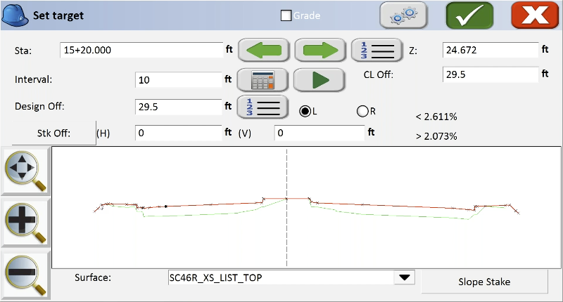
Advanced Roading
• Powerful Roading: favored by U.S. DOTs and heavy highway contractors around the world
• Comprehensive routines: Slope Staking, As-Built Topo with “Store Sections”, and more
• Advanced functionality for staking intersections and
culde-sacs using Carlson Road Network Files
Powered by Esri® (SurvPC Only)
• Powered by Esri: If ArcMap10, ArcView or equivalent reside on the same Windows tablet, SurvPC ‘finds’ the Esri engine and reads and writes Esri MXD files automatically, or SurvPC can be purchased with an Esri OEM engine built inside
• Intuitively use Esri Maps to perform all survey functions with no downtime learning new software
• Stake out, identify or draw to any existing feature by conventional ‘snap’ selection in Esri, DGN or .dxf
• Create new points in Esri, DGN or .dxf with symbols and formats native to the map
• Learn more in the SurvPC Esri Brochure
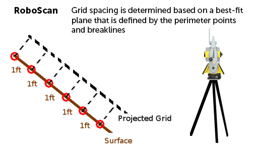
The RoboScan Workflow With Survey Grid
Use your robotic total station as a simple low density grid scanner with the RoboScan Workflow. This powerful tool, available in versions 5.05 and higher, can use the RoboScan Workflow With Grid Scan to take reflectorless shots along a grid that you define, automating the collection of numerous points in a few short steps.

Comprehensive Functionality
Carlson SurvPC is renowned for its comprehensive functionality that caters to the needs of surveyors and engineers alike. It supports a broad spectrum of equipment, including the latest RTK GPS systems and conventional or robotic total stations. This ensures that you have the flexibility to use the best tools available for your specific tasks, enhancing accuracy and efficiency in the field.
Integration with Esri GIS
One of the standout features of SurvPC is its seamless integration with Esri GIS. The software can load Esri maps and operate natively within the Esri GIS environment, making it a powerful tool for GIS professionals. This integration allows for real-time mapping and data collection, which is essential for accurate and up-to-date GIS projects.
Additionally, with the Esri OEM engine, users can work directly within the Esri GIS environment, ensuring compatibility and ease of use for those familiar with Esri products. This feature is particularly beneficial for complex projects that require detailed GIS data and analysis.
Enhanced Hardware Capabilities
SurvPC leverages the enhanced hardware capabilities of modern Windows PCs, including ruggedized laptops. This includes increased processing power, greater virtual memory, and the ability to handle large datasets. These enhancements mean that you can work more efficiently, with fewer interruptions and faster processing times.
User-Friendly Interface
The user interface of SurvPC is designed for ease of use, with larger screen sizes and more convenient touch screen functionality. This makes it easier to navigate and utilize the software, even in challenging field conditions. The intuitive design ensures that both novice and experienced users can operate the software effectively.
Advanced Data Management
SurvPC excels in data management, with features that allow for direct saving to Esri geodatabases without the need for import/export processes. This streamlines workflows and reduces the potential for data errors. The software is also compatible with Carlson office products, supporting file formats such as .fld and .flc, which further enhances its versatility.
Import and export capabilities for MicroStation .dgn files and AutoCAD .dwg files are included, making it easy to integrate SurvPC with other CAD and GIS applications. This interoperability is crucial for projects that involve multiple software platforms and data sources.
Real-Time Data Collection and Mapping
With the RD Map™ app, SurvPC enables real-time data collection and mapping. The app uses Bluetooth to connect to the locator and obtain GPS positional information, creating detailed maps of buried utilities. This real-time capability is essential for accurate field data collection and immediate analysis.
The RD Map™ app supports various file formats, including CSV and KML, which can be easily shared via email or messaging systems. This ensures that data collected in the field can be quickly and efficiently communicated to team members or clients.
Automated Usage Logging
SurvPC models equipped with GPS (indicated by models ending with 'G') automatically log key locate parameters every second. This automated logging provides a comprehensive record of field activities, which can be used for compliance verification, training assessments, and internal audits. The data generated is invaluable for ensuring best practices and improving overall field operations.
Usage data can be exported in multiple formats, such as KML for Google Maps, to provide a visual confirmation of work performed. This feature supports transparency and accountability in field operations, making it easier to track progress and verify task completion.


